
The Boundary
October 2014 Filed in: Human Landscapes
“No birds sing” Kitt’s Grave
At this time of year, our thoughts often turn to the grim and grisly end of autumn – All Hallow’s Eve – where, according to tradition, the veil between the physical and spiritual worlds is at its most porous. It is when, if the right arcane instructions are followed, travel between the realms is apparently possible but, as you will see, our physical boundaries – the liminal spaces at the edges of the parish – may hide gruesome secrets of their own.
It’s well known that criminals and suicide victims – also once considered guilty of ‘self-murder’ – were, throughout history, buried at crossroads. What might be a surprise is that unconsecrated burial is often found on parish boundaries and, frequently, where the border of three or more parishes came together.
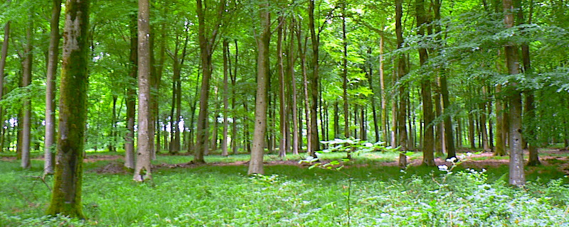
Kitt’s Grave on Cranborne Chase is the last resting place of either an old Romany woman, who is buried where she wandered her whole life – between the parishes of Martin, Pentridge and Bowerchalke – a highwayman who was hanged and buried there for his crimes, or a sad girl who drowned herself in a well. The grave – likely a long-since ploughed-out Bronze Age tumulus – is mentioned in historic charters and correspondence, as is a gallows erected there by the kindly Abbess of Wilton during the 16th century. There has been a meeting of three boundaries here for at least a millennium; first Saxon monastic estates, later parishes and counties. There’s a touch of the numinous about the spot, though, on my spring visit there, the passerines belting out their fruity warbles clearly hadn’t received the memo stipulating that ‘no bird sings’, as the old legend insists.
Further north in the Orkney Islands, two graves on the parish boundary that straddles the Water of Hoy are those of forlorn souls. Betty Corrigall’s fibreglass gravestone may seem a little anachronistic, but it was fashioned 200 years after her passing – with three exhumations of her remains in the twentieth century, her death has been almost as restless as her life, which she ended when her lover deserted her. A tiny island in the nearby lochan, meanwhile, has the grave of Thomas Bremner, jilted just before he was to be married in 1827.
In Suffolk, to the north of the pretty village of Moulton, where a crossroads on the ancient Icknield Way intersects with the Cambridgeshire border a ‘gypsy shepherd boy’, who lost a sheep and hanged himself in fear of the consequences, is reputedly buried here. Though apparently well-tended with flowers and votive offerings, the grave is probably from the 17th century. Its attention comes from its link with nearby Newmarket races, where the colour of the flowers apparently signifies the winning jockey. Lucky for some.
Comments
Standing Stones
September 2014 Filed in: Reading the Landscape | Buildings and Architecture
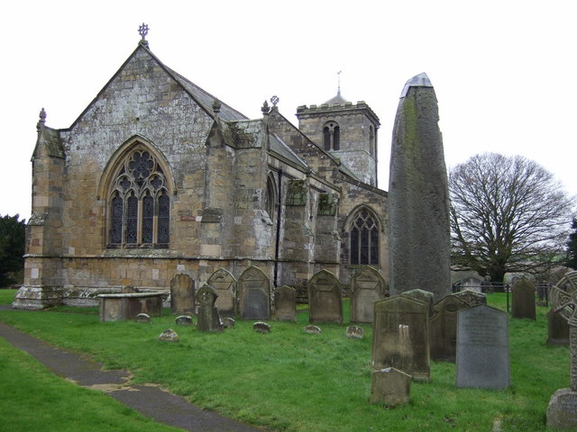
Rudston Monolith and All Saints Church
© J Thomas. Licensed for reuse under this Creative Commons CC-BY-SA-2.0 license via Geograph
There is something about standing stones that is strangely captivating. Their peculiar, ambiguous form draws your attention first; the way that many menhirs – an alternative name that translates as ‘long stone’ in Cornish or Breton – appear as isolated, accusing fingers that do little but point at the sky lends them an air of mystery. Then there is the extravagant effort required to quarry, transport and erect them when our ancestors must have had other calls on their time. Finally there is the question of purpose. Are they ancient memorials, avatars of the ancestors still at large in the landscape or did they have a more prosaic function?
One thing is sure, whatever it was that drove Britain’s various megalithic cultures, it is entirely lost to us now and we might have to make do with the patina of mystique that remains, along with the consolation that visiting our most interesting stones inevitably leads us to some corners of Britain that are interesting in their own right.
Whatever the stones were for, they were certainly part of a wider landscape upon which our ancestors saw fit to erect stone circles, dolmen, barrows, avenues and other pieces of Neolithic or Bronze Age funerary field furniture. In a few cases, they are found in a small group of other stones that form rows or odd arrangements and for which there is frequently a legend attached.
One of the most bizarre arrangements of stones is at the Mên-an-Tol on Penwith in Cornwall – a holed stone, about a metre high, is aligned between two short standing stones, almost certainly not in their original positions. It’s thought to be part of a former circle with the holed stone probably a part of a long-forgotten nearby tomb, but in its rearranged form it is associated with a treasury of miracles, from healing rickets to magical fertility rites.
At Rudston in the East Riding of Yorkshire, the Devil was supposed to have thrown a stone at the church and missed, but Rudston Monolith was here long before the church and at 7.6m (25 feet) high – Britain’s tallest – and 40 tons in weight, it easily matches its younger cousin in terms of gravitas.
Scotland’s tallest, Clach-an-Truiseil – the Stone of Compassion – a stone’s throw from the northwestern coast of Lewis in the Western Isles, stands at 5.8m (19 feet) and is meant, like many menhirs, to signify the site of a battle, although it’s actually the sole surviving monolith from a complete circle, of which there are no shortage on Lewis. Although it now stands alone, its original purpose was surely about making a connection – one that has endured between its builders and the landscape for 5000 years.
A Moving Tale: Roadside Crosses
August 2014 Filed in: Reading the Landscape | Buildings and Architecture
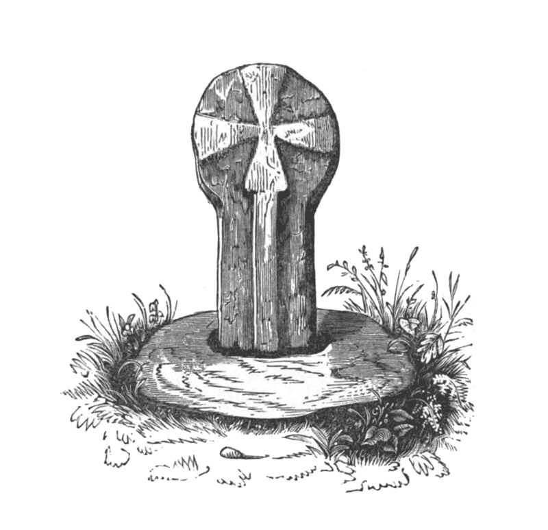
Boswarthen Cross, Madron. From Ancient Crosses and Other Antiquities in the West of Cornwall John Thomas Blight 1856
If you’re off on your summer holidays soon, it’s likely that you are not only getting ready for a long journey to the beach, airport or woodland cottage of your dreams, but also preparing for the familiar chorus of ‘are we there yet’ from the back seat. Passing on Robert Louis Stevenson’s adage that it’s “better to travel than arrive” to children is all very well but, despite his interest in pirates, Stevenson never had to drive the family down to Cornwall in a hatchback.
Long trips feel shorter for everyone when the sights and sounds distract from the monoculture of asphalt and white lines. Instead of just commuting to your holiday this year, why not investigate the road and the romantic tales of travel it offers. Indeed, a variety of monuments erected as waymarks, memorials or commemorations of epic voyages of the past can be found in Britain’s verges.
Most of them take the form of the roadside cross which, in Britain, are distributed north and west of the Jurassic line that runs from Dorset to the Tees and marks where upland and lowland meet. A few crosses crop up to the east of this line on the chalk; one such is Fat Betty – often called White Cross – on the North York Moors just south of the Castleton to Rosedale road. Betty has a square, squat base that carries a tiny round head on which the cross itself is inscribed. She also serves as a boundary marker and like much ancient roadside furniture, there is a story attached which links her to other nearby stones and crosses.
Elsewhere, crosses like Boswarthen, near Madron in Cornwall, are sometimes used to mark a route of pilgrimage. Boswarthen stands close to the path that leads to Madron Well, where ‘clooties’ of cloth hang from the trees, slowly rotting away – so the legend has it – as the well’s waters heal the sick.
A set of elaborately decorated crosses adorn the route of a medieval funeral cortege between Lincoln and London. These are the Eleanor crosses; twelve were originally erected in wood between 1291 and 1294, but were later replaced in stone. They mark the twelve day journey of the body of Eleanor of Castile, the wife of King Edward I – each cross was erected at a place where the Queen’s body rested for the night. Of the twelve, only three remain – at Geddington and Hardingstone in Northamptonshire and Waltham Cross in Hertfordshire. A Victorian replica of the original Charing Cross – destroyed by Parliamentarian forces in 1647 – now stands in the forecourt of the railway station named in its honour. As Stevenson would say himself: “Travel for travel’s sake. The great affair is to move.”
Behind the Seaside
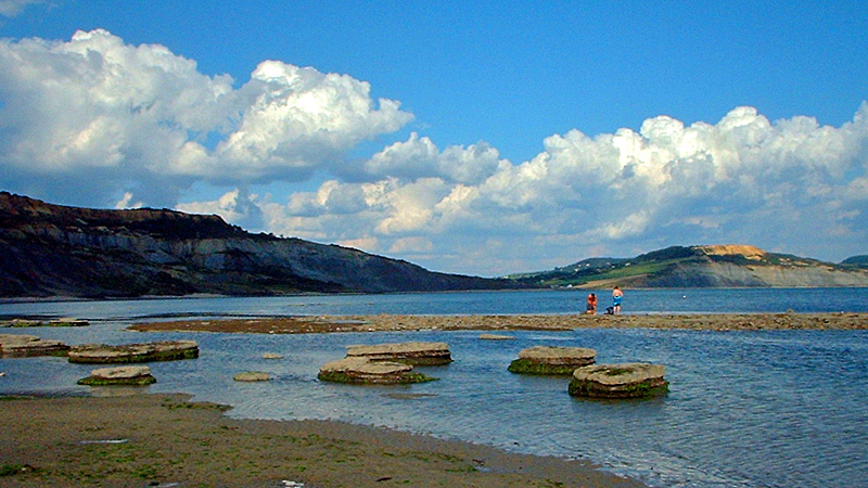
Golden Cap, as seen from Broad Ledge at Lyme Regis. © Ian Vince
As July advances, more and more of us make a bee-line for the beach to enjoy a day beside the seaside, but there’s more to the coast than just sandcastles and ice-cream cones (obviously important as they are). The sea is endlessly fascinating – especially now it has calmed down enough to stop taking huge chunks out of the shoreline, as was the case for most of the winter – but there are interesting details to note when you turn around and appreciate the hinterland, because for most of our islands’ 6000 miles of coastline, you’ll be looking at a cliff.
The cliffs around our shores tell us a lot about the processes that have shaped our islands and even a cursory study of the various forms they take can be fascinating. Cliffs are usually the products of gradual erosion but sometimes can also be the scene of extraordinary rock falls and landslides and nowhere are there better examples of this mix than the south coast of England.
The highest cliffs on the English Channel are those of Hardown Hill, near Charmouth or, to use its more celebrated name, Golden Cap, which stands at 191 metres – around 637 feet above the beach. At the mid point of the Jurassic Coast, the area’s geology makes landslips and rock falls common, especially after wet weather. Landslips occur when a porous layer of rock – sandstone, chalk or limestone – overlie an impermeable layer, usually of clay. The water percolates through the porous rock and then lubricates the top of the clay until the rock on top slides away. There’s a spectacular example of a landslip between Lyme Regis and Seaton, halfway up the cliff. A five mile-long coast path that hugged the ‘undercliff’ here formerly ran all the way through this NNR, an amazing landscape known locally as the Elephants’ Graveyard, but it’s now closed near Culverhole Point because of further slips. A there-and-back expedition’s still possible as of writing, but see southwestcoastpath.com for the latest news.
Rock falls are the product of more gradual processes than landslips and part of the evolution of the coastline which forms caves, arches, stacks and stumps in the piecemeal retreat of the cliff-line. Caves form when wave action erodes away a weakness in a cliff and when caves are on a headland – like those along the coast around Lulworth Cove – the erosion can work all the way through to make an arch, like the famous formation at Durdle Door or the Green Bridge of Wales on the Pembrokeshire coast. When the arch roof collapses, a stack remains and when the stack is undercut it leaves a stump, forevermore covered at high tide.
The Churchyard
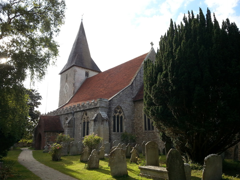
© 2014 Ian Vince | Bosham Church, West Sussex
The American poet and historian Abba Gould Woolson once wrote that, ‘since all this loveliness cannot be Heaven, I know in my heart it is June’. You can’t help wondering how she might have felt in a churchyard this month, where the occupants are theologically, metaphorically and ecologically in both kinds of Paradise at once; a garden of early summer, earthly delights where the veil between the worlds – as on St John’s Eve, later in the month – is tantalisingly thin.
The Litten, or God’s Acre – and it averages out at around an acre for each of Britain’s 23,000 or so churchyards – is evidently not just a quiet place for the dearly departed, but a grassland habitat full of life. Yellow meadow ants build their nests among the gravestones, bees and butterflies appreciate the wildflowers as do moths like the beautiful five-spot burnet and birds sing from the yew and holly trees. They are here because the churchyard has a kind of permanence and has typically been managed with a light touch for hundreds of years since its foundation. Often the history of the plot is deeper; a few ancient graveyard yews even pre-date Christianity in Britain.
Our reverence for churchyards has helped in their conservation, but that’s not to say that they haven’t changed over the years or been subject to the same whims that have informed the spires, battlements, porches, architectural noodlings and decoration on the churches themselves. The foundation of a Christian place of worship in the first place was the most profound of these changes and may have taken place on already sacred ground – a round churchyard may indicate a pagan site, as would large sarsens in the stonework or menhirs close by.
Churchyards were often a lot less peaceful in the past; records exist of Saxon ‘moots’ or parliaments convened and markets held and – as seen in the south porch of St Leonard’s in Thorpe, Derbyshire – you might find 14th century notches in the stonework where archers sharpened their arrows for target practise after Sunday service. There might even have been the flurry of pagan Morris dancers, some wrestling or cockfighting going on and the ‘church ale’ a kind of early beer festival in aid of the parish vestry.
Where God’s Acre now appears larger than an acre, the original churchyard can sometimes be traced by a subtle rise in ground level or by searching for the oldest headstones – until the 1700s they were inscribed on their ‘backs’ – to determine the extent. The churchyard would normally, though not always, have less space on the north side, where the ne’er-do-wells and criminals were buried, forever resting in shadow, even on a bright June day.