
Human Landscapes
The Boundary
October 2014
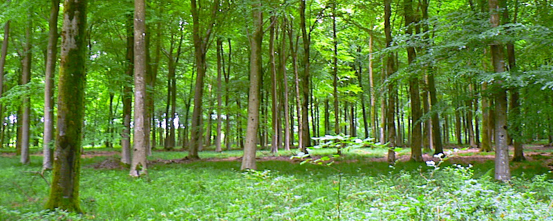
“No birds sing” Kitt’s Grave
At this time of year, our thoughts often turn to the grim and grisly end of autumn – All Hallow’s Eve – where, according to tradition, the veil between the physical and spiritual worlds is at its most porous. It is when, if the right arcane instructions are followed, travel between the realms is apparently possible but, as you will see, our physical boundaries – the liminal spaces at the edges of the parish – may hide gruesome secrets of their own.
It’s well known that criminals and suicide victims – also once considered guilty of ‘self-murder’ – were, throughout history, buried at crossroads. What might be a surprise is that unconsecrated burial is often found on parish boundaries and, frequently, where the border of three or more parishes came together.
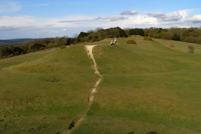
Kitt’s Grave on Cranborne Chase is the last resting place of either an old Romany woman, who is buried where she wandered her whole life – between the parishes of Martin, Pentridge and Bowerchalke – a highwayman who was hanged and buried there for his crimes, or a sad girl who drowned herself in a well. The grave – likely a long-since ploughed-out Bronze Age tumulus – is mentioned in historic charters and correspondence, as is a gallows erected there by the kindly Abbess of Wilton during the 16th century. There has been a meeting of three boundaries here for at least a millennium; first Saxon monastic estates, later parishes and counties. There’s a touch of the numinous about the spot, though, on my spring visit there, the passerines belting out their fruity warbles clearly hadn’t received the memo stipulating that ‘no bird sings’, as the old legend insists.
Further north in the Orkney Islands, two graves on the parish boundary that straddles the Water of Hoy are those of forlorn souls. Betty Corrigall’s fibreglass gravestone may seem a little anachronistic, but it was fashioned 200 years after her passing – with three exhumations of her remains in the twentieth century, her death has been almost as restless as her life, which she ended when her lover deserted her. A tiny island in the nearby lochan, meanwhile, has the grave of Thomas Bremner, jilted just before he was to be married in 1827.
In Suffolk, to the north of the pretty village of Moulton, where a crossroads on the ancient Icknield Way intersects with the Cambridgeshire border a ‘gypsy shepherd boy’, who lost a sheep and hanged himself in fear of the consequences, is reputedly buried here. Though apparently well-tended with flowers and votive offerings, the grave is probably from the 17th century. Its attention comes from its link with nearby Newmarket races, where the colour of the flowers apparently signifies the winning jockey. Lucky for some.
Comments
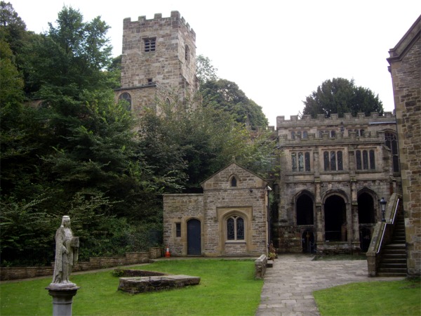
The Churchyard
June 2014
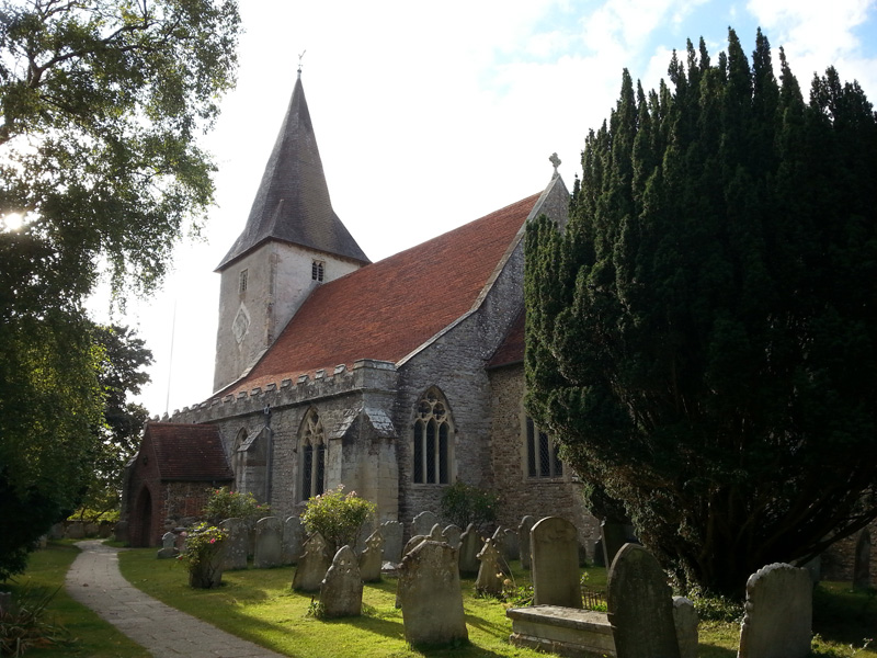
© 2014 Ian Vince | Bosham Church, West Sussex
The American poet and historian Abba Gould Woolson once wrote that, ‘since all this loveliness cannot be Heaven, I know in my heart it is June’. You can’t help wondering how she might have felt in a churchyard this month, where the occupants are theologically, metaphorically and ecologically in both kinds of Paradise at once; a garden of early summer, earthly delights where the veil between the worlds – as on St John’s Eve, later in the month – is tantalisingly thin.
The Litten, or God’s Acre – and it averages out at around an acre for each of Britain’s 23,000 or so churchyards – is evidently not just a quiet place for the dearly departed, but a grassland habitat full of life. Yellow meadow ants build their nests among the gravestones, bees and butterflies appreciate the wildflowers as do moths like the beautiful five-spot burnet and birds sing from the yew and holly trees. They are here because the churchyard has a kind of permanence and has typically been managed with a light touch for hundreds of years since its foundation. Often the history of the plot is deeper; a few ancient graveyard yews even pre-date Christianity in Britain.
Our reverence for churchyards has helped in their conservation, but that’s not to say that they haven’t changed over the years or been subject to the same whims that have informed the spires, battlements, porches, architectural noodlings and decoration on the churches themselves. The foundation of a Christian place of worship in the first place was the most profound of these changes and may have taken place on already sacred ground – a round churchyard may indicate a pagan site, as would large sarsens in the stonework or menhirs close by.
Churchyards were often a lot less peaceful in the past; records exist of Saxon ‘moots’ or parliaments convened and markets held and – as seen in the south porch of St Leonard’s in Thorpe, Derbyshire – you might find 14th century notches in the stonework where archers sharpened their arrows for target practise after Sunday service. There might even have been the flurry of pagan Morris dancers, some wrestling or cockfighting going on and the ‘church ale’ a kind of early beer festival in aid of the parish vestry.
Where God’s Acre now appears larger than an acre, the original churchyard can sometimes be traced by a subtle rise in ground level or by searching for the oldest headstones – until the 1700s they were inscribed on their ‘backs’ – to determine the extent. The churchyard would normally, though not always, have less space on the north side, where the ne’er-do-wells and criminals were buried, forever resting in shadow, even on a bright June day.
The Village Pond
April 2014
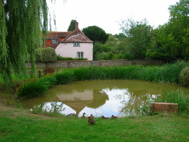
Village Pond and Residents, East Dean, Sussex. © Copyright Simon Carey and licensed for reuse under this Creative Commons Licence.
In the opening decades of the twenty-first century, the village duck pond might seem like a quaint anachronism, a little out of step with modern life, perhaps, despite its obvious charms as a wildlife haven and somewhere to relax awhile. For all its modern serenity, however, the village pond was once a place where the scene would be far from quiet and the pond and its green would be at the very centre of village life. Perhaps hard to believe at this time of year, when the tadpoles begin to climb the slippery pole of survival and natural life flourishes all around them, but for their medieval builders, ponds were huge undertakings and aesthetics were probably the last things on their minds.
Like the village green it is part of, the pond is often common land, a communal facility for the use of the whole village. Historically the village pond is likely to have provided fish – pisciculture was conducted with great enthusiasm in the Middle Ages – and would have been also used for soaking cartwheels (to prevent them from shrinking), washing clothes and as a watering hole for cattle, either grazing on the green itself or providing water for itinerant droves on the move to market or up the valley for summer pasture.
Once those cattle were safely moved up to the downs, another kind of artificial pool, the dew pond, would come into its own. Chalk, limestone and sandstone are porous and, as a result, surface water is absent; dew ponds – sometimes known as mist or cloud ponds – are saucer-shaped circular pools up to eight feet deep at the centre and often constructed in a slight hollow on a hill top. They were made between September and April by touring workers – it would take four men four weeks to make a large dew pond.
Traditionally-made dew ponds are lined by puddled clay, though chalk can also be puddled by reducing it to a powder, adding water until it is the consistency of clotted cream, smoothing it out and letting it dry, whereupon it becomes completely impermeable and better suited to the task than the Portland cement sometimes used by modern contractors.
Once built, the pond is then – confusingly – not filled by dew (or mist) at all, but by rainfall, while the dew pond’s position in a slight hollow helps keep the water cool and reduces loss by evaporation.
Claims are made that the two dew ponds of Chanctonbury Ring on the South Downs in Sussex date back to the Neolithic, but the oldest recorded dew pond is Oxenmere on Milk Hill in Wiltshire, which is named in a Saxon boundary charter of 825 CE/AD.
Stone Walls
January 2014
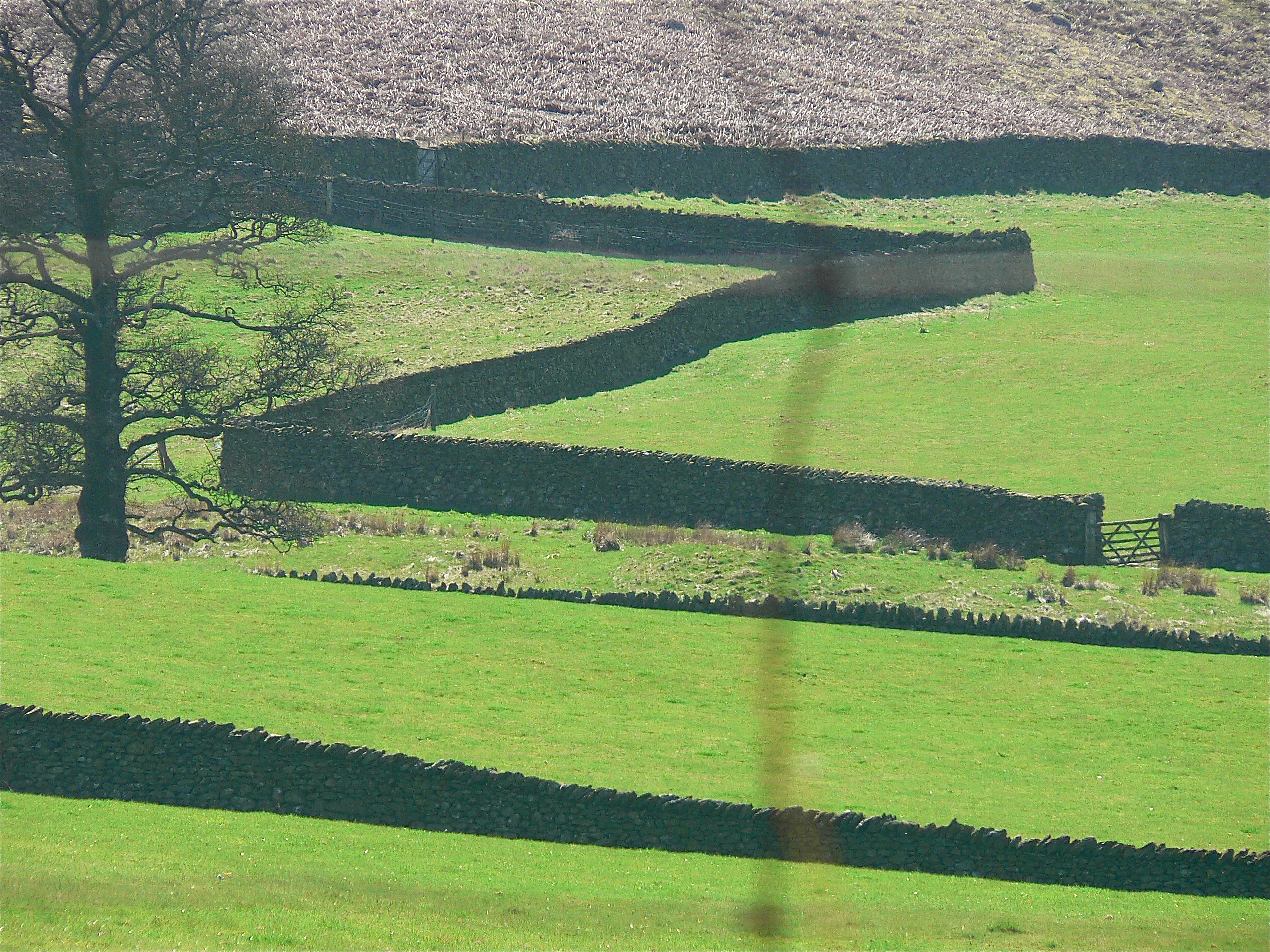
Like many areas of upland Britain, carns and quoits, tumuli, standing stones and a host of other familiar megalithic field furniture dominates the commons of West Penwith – the Lands End peninsula – but there’s one ancient artefact that barely gets a look-in, the landscape itself.
From the downs above Zennor and Boswednack, this landscape appears as an assembled patchwork; panels of pasture and meadows, an irregular hotchpotch of small enclosures sewn together by the seams of dry stone walls known locally as ‘Cornish hedges’, many of which boast a Bronze Age origin – archaeology recovered from the field walls themselves confirms that they are the oldest working artefacts in the world.
Nobody is quite sure, but there are thought to be around 125,000 miles of dry stone wall in Britain, mainly in upland areas north and west of the Tees-Exe line, where hedges don’t survive well, but also where the materials to build them are freely available. Construction is demanding.
A shallow foundation is dug – between 70 and 90cm wide – and large stones that can take the load of the wall are laid in this trench, the faces of the wall, which tapers towards the top ‘coping stones’ where it will be just 30cm wide, are laid next and the core is filled with looser rubble. At periodic intervals, a course of ‘through stones’ ties the two sides together.
It takes around two tonnes of stone to build every metre of wall and, ideally, all of that should come from the field that the wall is in. In that way, at least, every wall not only forms part of the landscape but is also formed by the landscape, so much so that the dedicated landscape reader can deduce rich detail about local geology simply by looking at a wall.
Not only local geology, but ownership as well – if a wall is over five feet, it’s probably a boundary as well as a field wall – while the march of walls across the landscape is also a chronicle of our relationship with the land. In Anglo-Saxon times, for instance, agriculture was concentrated in the lowlands where it was more successful with the techniques of the day and it wasn’t until the twelfth century enclosures of the Cistercians that dry stone walling made a come-back – indeed you can still see medieval field walls at Fountains Abbey in North Yorkshire.
The history of dry stone walls is also the history of the enclosures that started in the fifteenth and lasted until the nineteenth century; the story of the agricultural invasion of the uplands, culminating in the Parliamentary Enclosures of the eighteenth century when swathes of moorland commons were walled off to graze sheep.
Holloways and Green Lanes
November 2013
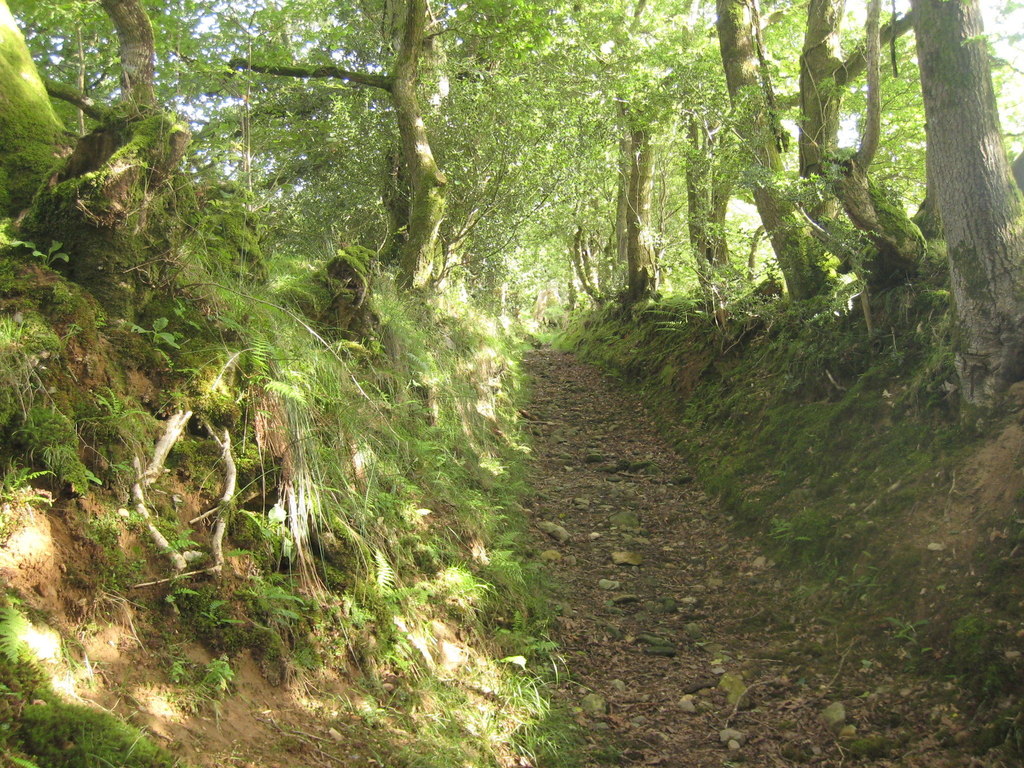
Of all the various roads and paths that snake their way through the countryside – A roads, B roads, byways and bridleways – it’s interesting to note that some ways are invested with a little more romance than the rest and by some ways, I mean green lanes and holloways.
While ‘green lane’ is a catch-all for many different kinds of unsurfaced rural road or path – such as an old drove, a coffin road or a ridgeway – a holloway is a more specific term. It describes a sunken green lane, a track which was been worn down by the passage of thousands of feet, cartwheels and hooves over hundreds of years, even millennia. With the loosened soil subsequently washed away by the next downpour, the course of a holloway will often become more pronounced on the side of a hill because of the extra energy imparted by the surface water run-off.
Holloways are common in lowland Britain with the greensands of the southern counties – Wiltshire, the Weald and the Chilterns – being particularly suited for their formation, as is the old red sandstone of the Wye and Usk valleys of Wales and the Marches, while the new red sandstone of south and east Devon has splendid, deep lanes on its slopes.
Over time, as they are inscribed ever more deeply and the level of the lane lowers, they become more sheltered and trees arch over, creating a womb-like tunnel, an enclosed place of natural safety. So safe, indeed, that it’s only around this time of the year that the walls of foliage have died back enough to get into some old lanes, long-since-abandoned by changing patterns of passage over the land, bypassed in favour of a better route.
Where holloways have fallen into disuse for even longer periods, they can be discovered anew – many centuries after they were last followed – by tell-tale shallow linear grooves through fields or woodland, though check that it’s not a short stretch of long-forgotten park pale or a defensive ditch, both of which will be accompanied by a bank above the natural ground level.
Holloways have their own atmosphere, an unexpected quality which cannot be explained away purely in terms of the local topography or geology. As ancient routes, they are the perfect expressions of collective will, tracks which share a common origin with desire lines – those unpaved paths across city parks or shortcuts over open ground that urban planners never anticipated. As travelling long distances was more difficult in the past, the reasons were more keenly felt; every footstep has meaning on a pilgrimage and the burdens shouldered on a well-used coffin road were more than the purely physical.
Trig Points
October 2013
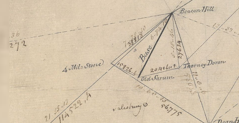
Just northeast of Old Sarum, the abandoned city that looms over younger, yet medieval, Salisbury, lies a monument important enough to be marked on Ordnance Survey maps, along with an intriguing inscription: ‘Gun End of Base’.
In many ways, it’s the most important point on the map, because if it wasn’t for Gun End of Base – actually the muzzle of a cannon buried vertically, business end up – there might not be a map at all. This is the spot where the first definitive mapping survey of Britain began in 1794, where initial measurements for the ‘principal triangulation of Britain’ were taken by Artillery man Captain William Mudge.
You can still see the snout of the cannon at Old Sarum, but the gun at Beacon Hill, 7 miles to the north where Mudge set his theodolite, was eventually replaced by a triangulation pillar, or trig point, 140 years later.
A small, tapered obelisk 4 feet tall and 2 feet square at the base, often found at the summit of a hill, the trig point is a welcome sight for walkers and climbers, although you don’t always need to scramble to the top of a draughty peak to bump into one; starting with Cold Ashby in Northamptonshire – in the middle of a rather flat field at SP644765 – there were around 6,500 built between 1936 and 1960, including one on the Little Ouse in Norfolk TL617897, a metre below sea level. Today, around 5,500 pillars remain at large, though only 110 remain in active service as part of a GPS-style network.
A familiar fixture in the British countryside since the OS built them to survey the country anew, the stability of trig points enabled surveyors to take very accurate measurements which allowed them to perform calculations that, in the trig point’s day, were accurate to 20 metres from one end of Britain to the other. Satellite technology has now improved that to just 3mm.
Trig points aren’t the only mapping artefacts you can discover in the field. Small metal plates marked with a broad arrow pointing up to a horizontal line, or ‘bench mark’, indicate a known height above sea level – and can be found on most pillars as well as the sides of churches, bridges and public buildings. They are joined by around half a million chiselled-out marks on walls all over Britain, which helped to define every last contour and spot height that appear on the map, often next to the triangular symbol that marks the trig point. And, as you catch your breath from the climb up to that pillar, you’ll see that if there’s one thing you can be sure of, it’s a fine view – of the next one.
Deserted Medieval Villages
September 2013
The eternal peril of its pubs and post offices aside, it’s hard not to view the British village as something of an indestructible institution, but it wasn’t always such a permanent fixture and the threats that it faces now pale into insignificance next to the menaces of the middle ages, when entire communities could be smeared from the map on the say-so of just one person.
The ‘Medieval Village’ label on Ordnance Survey maps carries an inevitable presumption of plague, but the spectre of a multitude of whole settlements exterminated by the Black Death is an exaggeration. Conspicuously large churches, like the magnificent St Mary’s at Tunstead in Norfolk where construction work was halted by the Great Mortality (as it was known at the time) are perhaps better indicators of the plague’s effect; villages were certainly weakened and reduced, but they were not always completely extinguished.
The real menace of the middle ages – the agent of chaos that threatened communities up and down the land – turns out to be nothing more than the humble sheep. Innocuous and dim as individuals, in farmed flocks their role as woolly bailiffs was well-established before, and for centuries after, the Black Death left its mark.
Cistercian monks were among the first to farm sheep on the enclosed lands of evicted villages. The Cistercian craving for isolation found expression in the destruction of villages like Cayton and Herleshow in Yorkshire in the twelfth century, both given to Fountains Abbey in return for eternal salvation for their noble freeholders, while tenants suffered the temporal damnation of being forced to move on.
The Black Death would play its own merry part later. With a reduced working population demanding better terms, the manorial lords, perhaps inspired by the Cistercians, filled their lands with sheep. Wharram Percy in the Yorkshire Wolds, the most famous of Britain’s 3,000 abandoned villages, was finally cleared in the early sixteenth century and enclosure continued in England for another three hundred years. From the seventeenth century on, enclosure was increasingly for country house emparkment, where designers like Lancelot ‘Capability’ Brown grazed on the profits of landscape enclosure in place of the sheep.
In Scotland, the ovine menace reared its ugly head once more in the infamous Highland Clearances of the eighteenth and nineteenth centuries. Some of the most brutal of the clearances occurred at Boreraig and Suisnish on the north shore of Loch Eishort on Skye; families were forcibly evicted and sent packing, their homes burnt down. Geologist Archibald Geikie who happened to witness the eviction in 1853 described the cortege that led north along the track from Suisnish and the grief-laden wail echoing along the strath as a ‘prolonged note of desolation’.
Saxon Churches
August 2013
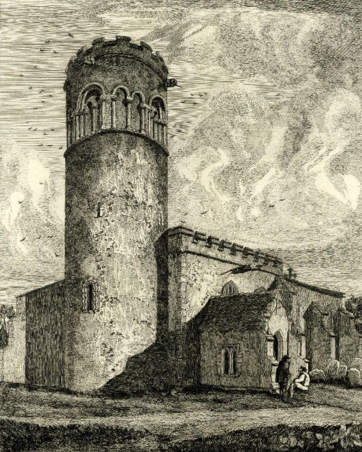
Above: Little Saxham in Suffolk - Most of Britain’s round Saxon church towers are in East Anglia
Church building being what it is – a rather drawn-out process that can occupy an entire generation or two, if not centuries – it’s perhaps no surprise that, nonconformist chapels aside, there are very few churches in Britain built wholly in one discreet architectural style. Given that Anglo-Saxon rule – from the early 5th century to 1066 – ended almost a millennium ago, it seems unreasonable to expect to find very much of their architecture left that hasn’t been substantially ‘improved’ upon or remodelled during the 950 years of fads and fashions that followed. But it is out there, you just have to look for the clues.
The most distinctive architectural indication is the triangular-headed window; where ever you see one, such as those at St Mary’s Deerhurst, four miles down the Severn from Tewkesbury, it’s conclusive evidence of a Saxon church, as is the tower’s herringbone masonry – a feature shown off to staggering effect at St Margaret of Antioch’s in Marton, Lincolnshire. Not all the windows have triangular heads, however, Saxon windows and doors often have rounded arches which can be distinguished from their Norman counterparts by chunkier stonework, particularly the roughly turned supporting pillars or ‘balusters’ which can call to mind over-engineered snooker table legs in their form.
Another strong, though similarly unfussy, detail is the Saxon pilaster, a thin, vertical stone column that bears a resemblance to the timbers found in Tudor vernacular architecture. Together with the string-courses that finish every storey of the tower at Earl’s Barton church in Northamptonshire, the half-timbered Tudor look is striking.
There’s good reason behind the unsubtle – and what many might regard as heavy-set – overtones of the Saxon church; the hammer and chisel didn’t make it into the stonemason’s toolkit until the second half of the 12th century and until that happened, Saxon, as well as early Norman, masons had to craft their stone with a hatchet.
As buildings that have been in continuous use for centuries, all old churches are works in progress and so their architectural features, historically, have always been at the mercy of fashion. There is one Saxon feature, however, that is present in almost every parish church built ever since, the tower. As part of a place of worship the tower is a Saxon invention which has been adopted into British church architecture in a variety of forms. Figuring among the Saxon forms of it are a smattering of rather beautiful round towers – most, like Little Saxham in Suffolk are located in East Anglia. The reason for this concentration of round towers might be geology; the local building stone is flint, which, because of the way it fractures, is very difficult to build corners with.
Name that Tumulus
June 2013
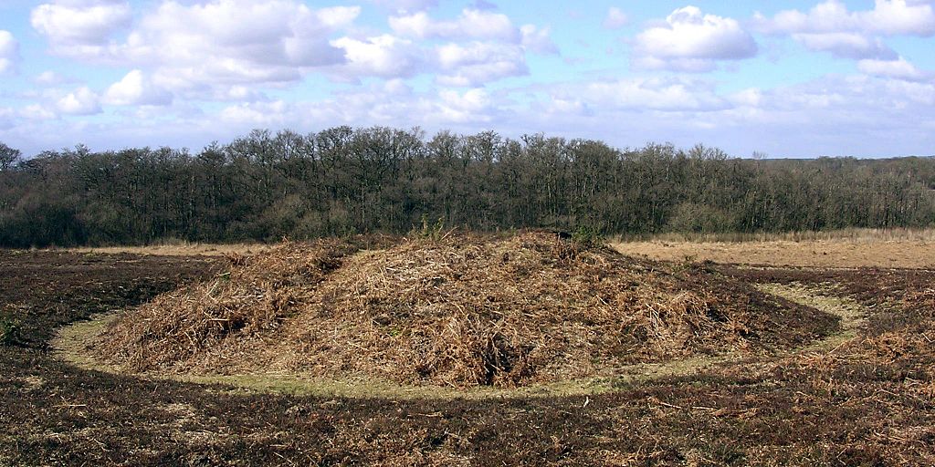
Above: A bowl barrow on the ridge on Matley Heath, near Ashurst in the New Forest, Hampshire. Image: © Jim Champion | CC BY SA 2.0
With up to 20,000 burial mounds in Britain and ‘tumulus’ a common word on Ordnance Survey maps, it’s not surprising that wherever you go, a barrow, howe, hump, or tump is never far away; of all the ripples and bumps on the land, barrows are the most abundant hummock of all.
They might be ubiquitous, but they’re far from uniform, occurring in a wide variety of shapes influenced by geology, the materials that were available and the shifting cultural trends of 4500 years. In some places, these different species of barrows occur as swarms around other features – especially henges (there are around 300 barrows in the immediate vicinity of Stonehenge alone) while others appear to have a relationship to parish borders – vestiges of Saxon estate boundaries which may, in turn, follow older territorial lines.
The most basic – and common – form of tumulus is the upturned dish shape of the bowl barrow (above), a burial mound that has adopted a consistent form throughout prehistory from the Neolithic on, even re-appearing in 6th century Saxon England as chieftains’ tombs. A simple barrow with a pleasingly rotund, roughly circular mound, usually surrounded by a ditch and an external bank, bowl barrows were built all over Britain, and most are between 5 and 40m across and up to 4m high.
The mounds of bell barrows (above) from the early Bronze Age on are separated from the ditch and bank that surrounds them by a narrow, level platform, or berm. They are most frequently associated with male burials and often contain daggers and other weapons among the grave goods. The ditch and platform can encompass up to four separate mounds, as can the ditch and bank of its refinement – the disc barrow (below) – which features a much smaller mound and wider platform.
While bell and disc forms are usually the graves of Bronze Age men, saucer barrows are predominately the tombs of women and can be recognized by a low, wide mound which extends without a berm to the ditch. Of the 60 in Britain, most are in Wessex, of the handful in Sussex, the best is at Chanctonbury Ring.
Of all the burial mounds, long barrows (below) are the oldest. There are around 300 of them in England and Scotland and a handful in Wales, all dating to the early Neolithic, contemporaries of the cromlechs and quoits of upland Britain. As the name suggests they are long – up to 125m – and they are usually the site of multiple interments. Their physical dominance of the landscape, and elaborate construction – some, like Belas Knap, Gloucestershire even have false entrances – inspired legends about their origin, the Wayland Smithy on the Berkshire Downs is a good example.
Drove Roads
June 2013
Among the oldest thoroughfares in Britain, drove roads were, for all practical purposes, the primary route network of their time. At their height between the Middle Ages and the Industrial Revolution, the roads linked the wild corners of Britain – particularly Scotland, Wales and the Westcountry – with the growing demands of towns and cities where livestock could be brought to market.
Extraordinary numbers of cattle and livestock were involved; in 1794, 10,000 cattle were exported from Anglesey alone, while 30,000 passed through Hereford each year. The routes from the north were just as busy; Scotland’s own extensive network of drove roads fed huge herds to fairs like the Falkirk Tryst, from where the cattle would begin an even longer journey south at the hands of their new owners. In 1663, 18,574 cattle were recorded on their way through Carlisle, while in Yorkshire during the early 19th century, up to 100,000 were herded each year towards Southern England on Hambleton Street, one of Britain’s most ancient trackways .
Cattle drovers steered clear of the settled population; for most of their length, routes ran over isolated ridgeways and kept away from villages, a strategy which had the added benefit of avoiding hefty turnpike fees and delays.
Many of the old tracks are known by their original names – Old Shaston and Ox Droves in Wiltshire, for example – while others take a little investigative work to discover. There are over a hundred hamlets and village streets called Little London in Britain – where Welsh drovers set up temporary communities on common land a short distance from an established village – and a nearby road or track called Welsh or Welshman’s Road, Cow, Bullock or Ox Lane, is likely to be the drover’s route itself.
Drove roads are broad for country lanes – anything between 40 and 50 feet across (12-15 m) is common, while a few are up to 90 feet (27 m) wide – with generous verges for grazing and dog-leg turns that provide shelter from the worse of the weather. The line of road is often marked by regularly spaced evergreens towering incongruously above the hedge-line, usually scots pine, laurel or holly, but sometimes yew, particularly in Hampshire. A clump of three or five evergreens together would mark a crossroads, a water-hole or an inn and where drovers stopped for the night, the cattle would graze – two-for-a-penny – in Halfpenny greens by the inns.
The railways brought centuries of droving to a rapid end and now, though the roads still run over the ridgeways of Britain, they are peaceful byways where the sweat and thunder of passing cattle is now supplanted by the whispering rustle of ramblers’ cagoules.
Springs and Wells
April 2013
As the first season of the year, spring brings a fresh start to the country calendar, while also sharing its name – and a common origin – with the word for the source of a stream, an Old English verb that means ‘to burst forth’.
An enduring human preoccupation, the availability of fresh water is one of the most dominant factors in shaping not only the landscape itself, but our subsequent use of it. In the spring line settlements of the North and South Downs, villages cluster around streams that flow from the base of the permeable chalk. Chalk may be porous, but on the Downs it lies over an impermeable clay and springs bubble to the surface where the two rocks meet. You can trace this concealed seam with the aid of nothing more specialist than a motoring atlas; the hidden geology that makes the spring line is betrayed by roads that run from village to village, parallel to the crest of the Downs.
Spring line settlements aren’t only found on chalk. Cheddar and Wells, at the base of the Mendips in Somerset, are spring line villages at the foot of limestone outcrops, while the dead-straight fifty-mile-long escarpment of the Lincoln Edge reveals a spring line settlement every mile or so.
In Cheshire, a ridge of various kinds of sandstone that runs north from Whitchurch includes one that is aptly named ‘waterstone’ on which springs abound. With fresh water widely available at the ridge’s foot, the pattern of settlement is dispersed and open; higher up the slopes, wells were excavated in the easily worked rock – one, within the inner bailey of Beeston Castle is over 350 feet deep.
In medieval times, the source of water not only satisfied a physical requirement, but could also fulfil a spiritual need. At the centre of reverence for water as the capricious, spiteful god it sometimes seemed to be, wells were credited with magical qualities; in that way at least, a holy well like, well, Holywell in Flintshire lived up to its epithet as the ‘Lourdes of Wales’, attracting thousands of pilgrims to take the waters long before spa towns like Cheltenham and Tunbridge Wells claimed medicinal benefit in the foul-tasting waters. But even the medieval holy wells are young in comparison to the wells of the celtic fringe. On the approach to Madron and Sancreed Wells in Cornwall and St Curiden’s spring on the Black Isle near Munlochy, hundreds of votive rags, or ‘clooties’ have been tied to the trees by visitors seeking a cure to an intractable illness - as the fabric disintegrates, runs the reasoning, so the illness is cured. Unfortunately, some have left offerings that are made from non bio-degradable fabrics.
Grim’s Dykes
March 2013
Bokerley Dyke snaking its way southeast. The Saxons would have tried to invade from the left
March may be the official start of spring, a little warmer and with promises to keep, but it also hides a dark secret, for the month has martial connections. Named after Mars, the Roman god of war, it was not only the start of the Roman year, but also the month for mounting military campaigns. Those campaigns, and many more before and since, have left obvious marks on the countryside; battlefields, motte and baileys and castle keeps we would all recognise the names of, from Hadrian’s Wall to the half-mile-long magnificence of Maiden Castle in Dorset, with medieval and Tudor strongholds the length of the country between. The ubiquity of battle and war in every corner of Britain is evidence of the part that conflict has played in our history, but for every famous hillfort, castle and Roman wall, there are dozens of military connections hiding quietly in our countryside.
Among them, the miles of Iron Age Grim’s Dykes or Ditches that are common in Wessex and are believed to be territorial markers. Though not of a sufficient scale for military use – where they can still be tracked on the ground they tend to be of the scale of a modest railway embankment – the ditches have an etymological cousin in Graham’s Dyke, a local name for the Roman’s short-lived Antonine Wall across the Central Lowlands of Scotland. Grim was the Old English name for the Anglo-Saxon god of war, Woden, and other Grim’s Ditches, particularly the one at Colton, east of Leeds, may have been substantial enough to have a defensive use.
Compared to Offa’s Dyke – up to 65 feet at its widest and at least 64 miles long – Grim’s Dykes may seem modest. The eponymous creation of the eighth-century King of Mercia, Offa’s Dyke marks the English-Welsh border (running along Marches of a different kind) and is a potent symbol of tension throughout history. The dyke is built to have commanding views of Powys to the west, with the bank on the Mercian side and the ditch in front to deter any hapless invaders from Wales.
Seven-hundred years before Offa, at Wales’ northwestern horn, advancing Roman legions were confounded by both the treacherous Menai Straits and the Celtic tribes of Ynys Môn (Anglesey) on the other side. Roman Governor Agricola inflicted a punishing and conclusive triumph over them in 78 AD, and Ynys Môn was taken for good, but the memory of his brutal campaign is allegedly preserved in the names of fields; close to Brynsiencyn on the island, one howls its name as Cae-oer-waedd or the ‘Field of Bitter Lamentation’, another is simply “The Field of the Long Battle”.
Ridges and Bumps
February 2013
Strip Lynchets at Coombe Hill, Wooton-Under-Edge, Gloucestershire. Photo credit: Synwell / Foter.com / CC BY-NC-ND
As January passes into February, halfway from winter solstice to spring but still the coldest part of the year, it often feels as if it is a distinct season of its own. With low grass in the fields, a touch of frost or a light dusting of snow can reveal a swarm of slumbering lumps, bumps and hummocks of every form, suddenly apparent in a landscape sculpted by the long shadows of the low sun.
Despite appearances, many of these undulations, earthen ripples and waves across the landscape, are not defensive earthworks, ramparts or relics of long-forgotten battles, but evidence of our ancestors’ struggle with the land itself – the remains of various ancient methods of farming – while some are the outcome of nothing more violent than the gradual creep of soil down a hill, occasionally exacerbated by the frolicking trot of sheep.
The most marked features are those shown on Ordnance Survey maps as ‘Strip Lynchets’, the consequence of ploughing along the contours of slopes to create a flat area for crops, as practised in medieval and, occasionally, even earlier times. Dorset and Wiltshire have the best examples – below the Ridgeway near Bishopstone in North Wiltshire and near the village of Loders near Bridport, where giant stair-flights climb the slope; it’s not for nothing that ‘risers’ and ‘treads’ have crept into the terminology of strip lynchets to describe the relevant parts. Further north, at Conistone in Upper Wharfedale and Hall Garth, near Great Musgrave in Cumbria, the effect is gentler, but just as striking.
On more level ground, a pattern of regular undulation can reveal another medieval farming practice – ridge and furrow. Vast open fields were cultivated in furlong (literally furrow-long) strips by tenant subsistence farmers. Working clockwise around their strip, their ploughs turned the sod inward, building up a shallow ridge at the centre of their strip and leaving furrows along the long edges. Hauled by a team of eight oxen, the turning circle in the headland was difficult to achieve without curving slightly to the left at the end of each furlong and a shallow reverse-S or C form to the ridge can often be detected.
In the angular light cast on a February day, far subtler features can be discovered. Thin bands known as terracettes – but sometimes called catsteps or sheep tracks – are formed by soil creeping down steep slopes over the years, a result of repeated saturation and drying. Where bare sedimentary rock is exposed, a light fall of snow might pick out its bedding planes, revealing a succession of sea beds over millions of years or even, on red sandstones, the swash of a desert dune – a geological comfort for the middle of winter.
Park Pale
December 2012
Low embankment, mostly covered in bushes, in Chawton Park Wood. The pale is probably an old royal park boundary and it could run alongside the alignment of a Roman road. Link
A familiar label, a ‘park pale’ – as rendered in Old English blackletter on Ordnance Survey maps – marks the ditch and bank that formed the boundary of a medieval deer park. On the ground they might still define an area of woodland pasture, while banks several metres wide, once surmounted by a palisade or, perhaps, still carrying a stone wall, can be substantial even after centuries. The ditch that runs on the inside of the bank is usually less distinct. Their design allowed deer to bound into the park, but prevented them from leaping out again, making the deer park like a huge, terrestrial lobster pot, harvesting meat for the aristocratic table.
It’s a fitting feature to investigate during the season of high octane food, not least because in the low-fat, calorie-counted, gastronomically-tightfisted twenty-first century, Christmas dinner is the closest most of us get to a proper medieval banquet – a seasonal version of which was likely to include venison, while the most kindly of lords might give their servants deer offal – or numbles – for baking into a numble pie.
The model on which the ornamental parks of the eighteenth century were based, the medieval deer park is a landscape tradition whose roots extend back to the Norman conquest. William the Conqueror, who was crowned as an English monarch on Christmas Day, 1066, famously created 36 Royal Forests in the twenty-one years of his reign, reflecting his enthusiasm for the chase. At first, keeping and hunting deer was exclusively the reserve of royalty, but licenses from the King gave members of the aristocracy and senior churchmen the right to hunt on their own lands and a mania for creating deer parks took hold. The remains of one such park – first recorded in 1291, but almost certainly older – can be seen on the eastern side of Lyndhurst in the New Forest, where the pale is 9 metres wide and its bank over a metre high. Another park pale is associated with Kenilworth Castle and Pleasance – Henry V’s manor house in Warwickshire – while the most outstanding example in Scotland is at Fettercairn in Aberdeenshire, where eight miles of pale around the King’s Deer Park may even pre-date the Norman conquest of England.
The frequent occurrence of the park pale on modern maps is a reflection of their ubiquity in medieval landscapes; deer parks covered as much as 2% of England at the start of the fourteenth century and had a political importance to match. While there was no shortage of deer parks, there were shortages of deer because noble huntsmen were rather good at killing their trapped quarry, quicker than they could be re-stocked by hapless deer bounding over the pale. With his large Royal Forests, the King could send deer to his more co-operative and influential lords.