
Jun 2013
Name that Tumulus
June 2013 Filed in: Human Landscapes | Lumps and Bumps
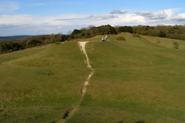
Above: A bowl barrow on the ridge on Matley Heath, near Ashurst in the New Forest, Hampshire. Image: © Jim Champion | CC BY SA 2.0
With up to 20,000 burial mounds in Britain and ‘tumulus’ a common word on Ordnance Survey maps, it’s not surprising that wherever you go, a barrow, howe, hump, or tump is never far away; of all the ripples and bumps on the land, barrows are the most abundant hummock of all.
They might be ubiquitous, but they’re far from uniform, occurring in a wide variety of shapes influenced by geology, the materials that were available and the shifting cultural trends of 4500 years. In some places, these different species of barrows occur as swarms around other features – especially henges (there are around 300 barrows in the immediate vicinity of Stonehenge alone) while others appear to have a relationship to parish borders – vestiges of Saxon estate boundaries which may, in turn, follow older territorial lines.
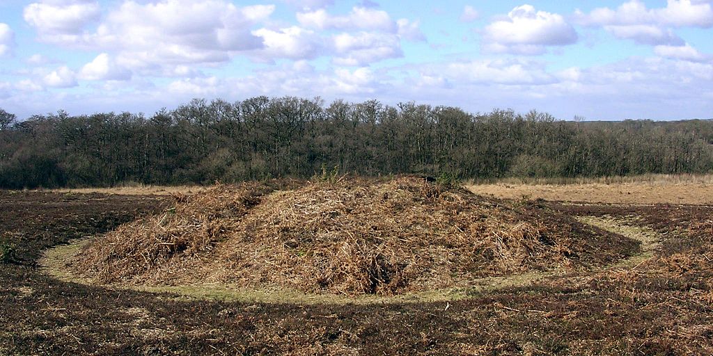
The most basic – and common – form of tumulus is the upturned dish shape of the bowl barrow (above), a burial mound that has adopted a consistent form throughout prehistory from the Neolithic on, even re-appearing in 6th century Saxon England as chieftains’ tombs. A simple barrow with a pleasingly rotund, roughly circular mound, usually surrounded by a ditch and an external bank, bowl barrows were built all over Britain, and most are between 5 and 40m across and up to 4m high.
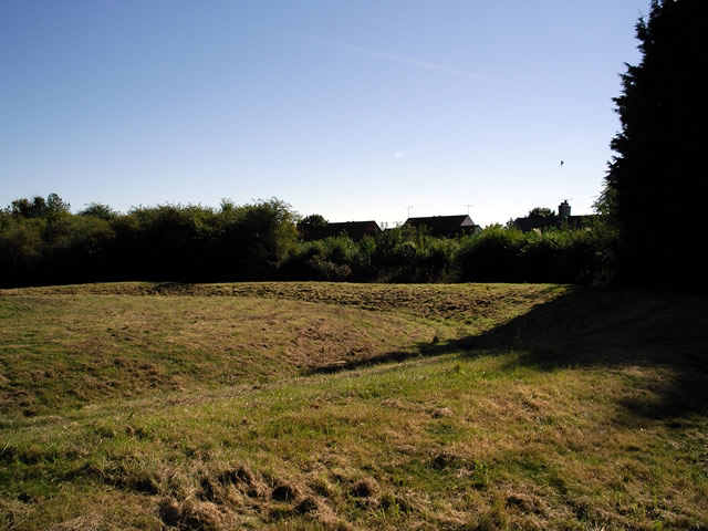
The mounds of bell barrows (above) from the early Bronze Age on are separated from the ditch and bank that surrounds them by a narrow, level platform, or berm. They are most frequently associated with male burials and often contain daggers and other weapons among the grave goods. The ditch and platform can encompass up to four separate mounds, as can the ditch and bank of its refinement – the disc barrow (below) – which features a much smaller mound and wider platform.
While bell and disc forms are usually the graves of Bronze Age men, saucer barrows are predominately the tombs of women and can be recognized by a low, wide mound which extends without a berm to the ditch. Of the 60 in Britain, most are in Wessex, of the handful in Sussex, the best is at Chanctonbury Ring.
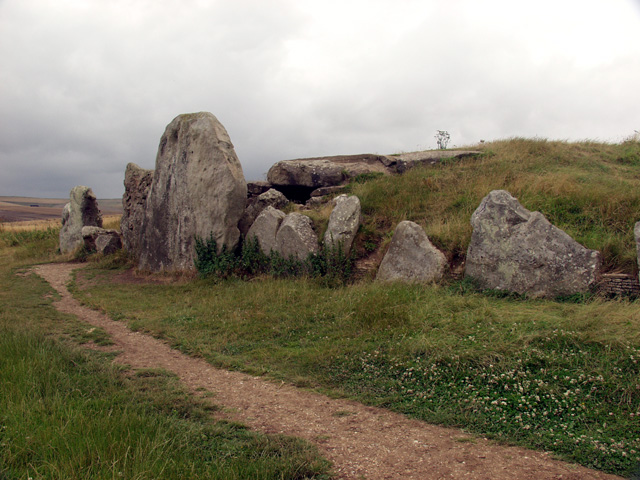
Of all the burial mounds, long barrows (below) are the oldest. There are around 300 of them in England and Scotland and a handful in Wales, all dating to the early Neolithic, contemporaries of the cromlechs and quoits of upland Britain. As the name suggests they are long – up to 125m – and they are usually the site of multiple interments. Their physical dominance of the landscape, and elaborate construction – some, like Belas Knap, Gloucestershire even have false entrances – inspired legends about their origin, the Wayland Smithy on the Berkshire Downs is a good example.
Comments
Drove Roads
June 2013 Filed in: Roads | Human Landscapes
Among the oldest thoroughfares in Britain, drove roads were, for all practical purposes, the primary route network of their time. At their height between the Middle Ages and the Industrial Revolution, the roads linked the wild corners of Britain – particularly Scotland, Wales and the Westcountry – with the growing demands of towns and cities where livestock could be brought to market.
Extraordinary numbers of cattle and livestock were involved; in 1794, 10,000 cattle were exported from Anglesey alone, while 30,000 passed through Hereford each year. The routes from the north were just as busy; Scotland’s own extensive network of drove roads fed huge herds to fairs like the Falkirk Tryst, from where the cattle would begin an even longer journey south at the hands of their new owners. In 1663, 18,574 cattle were recorded on their way through Carlisle, while in Yorkshire during the early 19th century, up to 100,000 were herded each year towards Southern England on Hambleton Street, one of Britain’s most ancient trackways .
Cattle drovers steered clear of the settled population; for most of their length, routes ran over isolated ridgeways and kept away from villages, a strategy which had the added benefit of avoiding hefty turnpike fees and delays.
Many of the old tracks are known by their original names – Old Shaston and Ox Droves in Wiltshire, for example – while others take a little investigative work to discover. There are over a hundred hamlets and village streets called Little London in Britain – where Welsh drovers set up temporary communities on common land a short distance from an established village – and a nearby road or track called Welsh or Welshman’s Road, Cow, Bullock or Ox Lane, is likely to be the drover’s route itself.
Drove roads are broad for country lanes – anything between 40 and 50 feet across (12-15 m) is common, while a few are up to 90 feet (27 m) wide – with generous verges for grazing and dog-leg turns that provide shelter from the worse of the weather. The line of road is often marked by regularly spaced evergreens towering incongruously above the hedge-line, usually scots pine, laurel or holly, but sometimes yew, particularly in Hampshire. A clump of three or five evergreens together would mark a crossroads, a water-hole or an inn and where drovers stopped for the night, the cattle would graze – two-for-a-penny – in Halfpenny greens by the inns.
The railways brought centuries of droving to a rapid end and now, though the roads still run over the ridgeways of Britain, they are peaceful byways where the sweat and thunder of passing cattle is now supplanted by the whispering rustle of ramblers’ cagoules.