
May 2013
Beside the Seaside
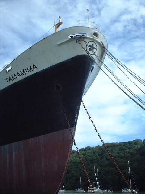
The Ukranian-crewed cargo ship, Tamamima, slowly rusting in the upper reaches of the Fal Estuary, close to the King Harry Ferry. More information on the Tamamima can be found here
While the rest of this special edition of the magazine takes to the canals and rivers of Britain, we couldn’t let the month pass without a look at the landforms that are found next to Britain’s most important waterway – one that you’re famously never more than 70 miles or so from in the UK – the sea. At nearly 20,000 miles long and formed from countless permutations of geology and topography, there’s a variety of features to see along the coastline of Britain.
Having said that, there are parts of Scotland that appear to have borrowed Nordic landforms – its north and west coast are punctuated by steep glacier-gouged fjords; each U-shaped valley terminating in sea lochs like Loch Broom by Ullapool or the glorious Loch Etive a few miles north of Oban. Although not as forbidding as their Norwegian counterparts, Scottish fjords share a heritage with the mountains of Scandinavia that goes beyond their glacial origins; they are part of the same mountain range – eroded to a fifth of its former height and torn apart by the same tectonic processes that opened up the Atlantic Ocean, while the rest of the range forms the Appalachians of the eastern USA.
At the other end of Britain, the drowned valleys or ‘rias’ of Cornwall and Devon are stunning examples of what happened when the glaciers melted. The rise in sea level – between 100-120 metres – inundated coastal valleys from Milford Haven in Wales around the coast to Southampton Water and the Solent. Among them, the Carrick Roads at Falmouth is the third deepest natural harbour in the world (after Sydney and Rio de Janeiro, since you ask), while five miles upstream and to all intents and purposes in the middle of the countryside, the channel is still deep enough to mothball container ships next to the chain-link King Harry Ferry. Despite the incongruity, like other rias – the Helford, the Fowey, the Tavy, Tamar and Dart, sylvan valleys with woods to the water’s edge and the odd bottomless boat slowly melting back into the river – the Fal maintains an air of tranquility.
Further east, Dorset’s Jurassic Coast displays a stunning set of landforms made by differential erosion; headlands of harder rock than the bays they frame, arches, sea-stacks and coves, but its most striking feature is Chesil Bank, an 18-mile long barrier beach that sweeps into the base of the Isle of Portland. It was originally described as Britain’s largest tombolo – a spit formed by refraction of currents around an island – but geomorphologists have changed their minds about that and say it only looks like one, transferring the honour further north among Shetland’s fjords – or voes – to the sandy tombolo that connects St Ninian’s Isle to the Mainland.
Comments