
Water
Behind the Seaside
July 2014
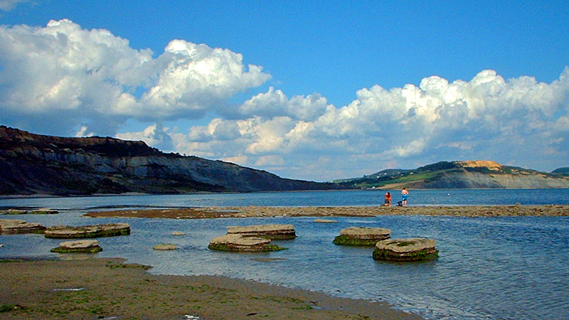
Golden Cap, as seen from Broad Ledge at Lyme Regis. © Ian Vince
As July advances, more and more of us make a bee-line for the beach to enjoy a day beside the seaside, but there’s more to the coast than just sandcastles and ice-cream cones (obviously important as they are). The sea is endlessly fascinating – especially now it has calmed down enough to stop taking huge chunks out of the shoreline, as was the case for most of the winter – but there are interesting details to note when you turn around and appreciate the hinterland, because for most of our islands’ 6000 miles of coastline, you’ll be looking at a cliff.
The cliffs around our shores tell us a lot about the processes that have shaped our islands and even a cursory study of the various forms they take can be fascinating. Cliffs are usually the products of gradual erosion but sometimes can also be the scene of extraordinary rock falls and landslides and nowhere are there better examples of this mix than the south coast of England.
The highest cliffs on the English Channel are those of Hardown Hill, near Charmouth or, to use its more celebrated name, Golden Cap, which stands at 191 metres – around 637 feet above the beach. At the mid point of the Jurassic Coast, the area’s geology makes landslips and rock falls common, especially after wet weather. Landslips occur when a porous layer of rock – sandstone, chalk or limestone – overlie an impermeable layer, usually of clay. The water percolates through the porous rock and then lubricates the top of the clay until the rock on top slides away. There’s a spectacular example of a landslip between Lyme Regis and Seaton, halfway up the cliff. A five mile-long coast path that hugged the ‘undercliff’ here formerly ran all the way through this NNR, an amazing landscape known locally as the Elephants’ Graveyard, but it’s now closed near Culverhole Point because of further slips. A there-and-back expedition’s still possible as of writing, but see southwestcoastpath.com for the latest news.
Rock falls are the product of more gradual processes than landslips and part of the evolution of the coastline which forms caves, arches, stacks and stumps in the piecemeal retreat of the cliff-line. Caves form when wave action erodes away a weakness in a cliff and when caves are on a headland – like those along the coast around Lulworth Cove – the erosion can work all the way through to make an arch, like the famous formation at Durdle Door or the Green Bridge of Wales on the Pembrokeshire coast. When the arch roof collapses, a stack remains and when the stack is undercut it leaves a stump, forevermore covered at high tide.
Comments
The Village Pond
April 2014
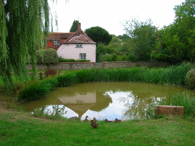
Village Pond and Residents, East Dean, Sussex. © Copyright Simon Carey and licensed for reuse under this Creative Commons Licence.
In the opening decades of the twenty-first century, the village duck pond might seem like a quaint anachronism, a little out of step with modern life, perhaps, despite its obvious charms as a wildlife haven and somewhere to relax awhile. For all its modern serenity, however, the village pond was once a place where the scene would be far from quiet and the pond and its green would be at the very centre of village life. Perhaps hard to believe at this time of year, when the tadpoles begin to climb the slippery pole of survival and natural life flourishes all around them, but for their medieval builders, ponds were huge undertakings and aesthetics were probably the last things on their minds.
Like the village green it is part of, the pond is often common land, a communal facility for the use of the whole village. Historically the village pond is likely to have provided fish – pisciculture was conducted with great enthusiasm in the Middle Ages – and would have been also used for soaking cartwheels (to prevent them from shrinking), washing clothes and as a watering hole for cattle, either grazing on the green itself or providing water for itinerant droves on the move to market or up the valley for summer pasture.
Once those cattle were safely moved up to the downs, another kind of artificial pool, the dew pond, would come into its own. Chalk, limestone and sandstone are porous and, as a result, surface water is absent; dew ponds – sometimes known as mist or cloud ponds – are saucer-shaped circular pools up to eight feet deep at the centre and often constructed in a slight hollow on a hill top. They were made between September and April by touring workers – it would take four men four weeks to make a large dew pond.
Traditionally-made dew ponds are lined by puddled clay, though chalk can also be puddled by reducing it to a powder, adding water until it is the consistency of clotted cream, smoothing it out and letting it dry, whereupon it becomes completely impermeable and better suited to the task than the Portland cement sometimes used by modern contractors.
Once built, the pond is then – confusingly – not filled by dew (or mist) at all, but by rainfall, while the dew pond’s position in a slight hollow helps keep the water cool and reduces loss by evaporation.
Claims are made that the two dew ponds of Chanctonbury Ring on the South Downs in Sussex date back to the Neolithic, but the oldest recorded dew pond is Oxenmere on Milk Hill in Wiltshire, which is named in a Saxon boundary charter of 825 CE/AD.
Beach Landforms
February 2014
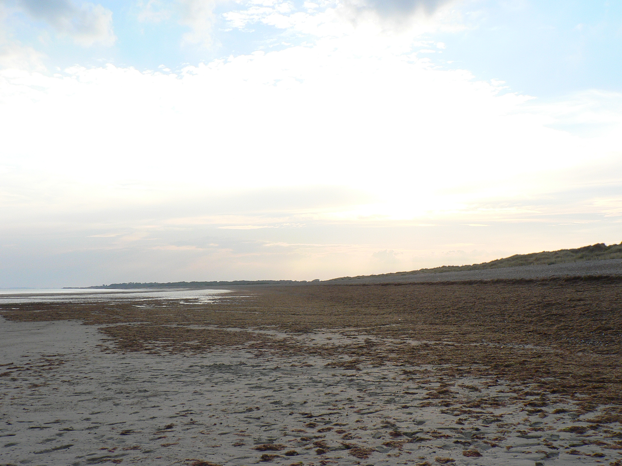
There’s nothing better at this time of the year than a walk along a breezy beach, to blow the cobwebs out of your brain. Aside from its potential to refresh, however, a beach is a unique environment, not least because it is where the normally slow processes that form landscapes occur comparatively quickly, rather than in ten million year blocks of deep time.
While even an ice age takes thousands of years to rise, subside and do its worst, beaches are the scene of constant renewal, with every wave that breaks on the shore adding and removing material. The cumulative effects are revealed over a year, a decade or a century, but in extreme conditions the coast can change even quicker; a storm can create or destroy entire landscapes before your eyes.
The main culprit behind all the heave-ho up and down the beach is longshore drift, a process where sediment-laden waves, blown by prevailing winds, hit the shore at an oblique angle and create a ‘swash’. Gravity then pulls the water, pebbles and sand back down the beach’s steepest gradient, generally at right angles to the shoreline. The passage of every grain of sand describes a zig-zagging, sawtooth pattern along the beach until it reaches another current, an obstacle like a groyne or a headland where the coastline changes direction.
Where the angle of the shore changes, the strength of the longshore current dissipates and drops the sediment, which build up to form a sandbar or spit. One of Britain’s best examples is at Orford Ness in Suffolk; you may be familiar with its elbow-like form from maps but, thanks to medieval cartographers we know it has assumed all sorts of shapes over the years, often growing over a metre a year.
Diffraction of waves around a spit leads to hook-like sandbanks – good examples abound on North Norfolk and Solent coastlines – but where they diffract around an offshore island, tombolos form. St Ninian’s Isle off Shetland’s Mainland and Asparagus Island at Kynance in Cornwall are good examples.
Longshore drift affects every beach, but not all spit-like structures are its creation. Barrier beaches like Slapton Ley in Devon were formed offshore and then rolled into their current position by rising sea levels, stopping when the beach reached higher ground. In Dorset, the lagoons behind Chesil Beach owe everything to timing – sea levels stopped rising around 5,000 years ago and halted the movement of the beach onto the land. Originally made from sand and gravel, Chesil’s creation coincidentally saw the sea reach cliffs in East Devon that has been cut off from the sea since the start of glaciation; and here, longshore drift supplemented the shingle.
Beside the Seaside
May 2013
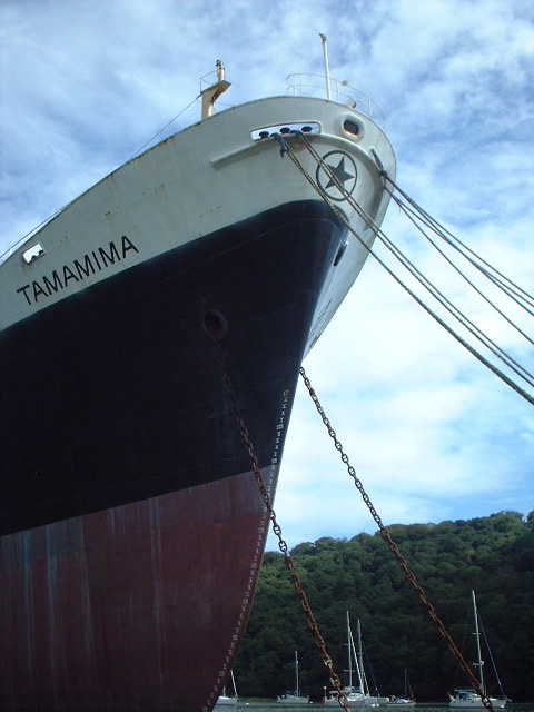
The Ukranian-crewed cargo ship, Tamamima, slowly rusting in the upper reaches of the Fal Estuary, close to the King Harry Ferry. More information on the Tamamima can be found here
While the rest of this special edition of the magazine takes to the canals and rivers of Britain, we couldn’t let the month pass without a look at the landforms that are found next to Britain’s most important waterway – one that you’re famously never more than 70 miles or so from in the UK – the sea. At nearly 20,000 miles long and formed from countless permutations of geology and topography, there’s a variety of features to see along the coastline of Britain.
Having said that, there are parts of Scotland that appear to have borrowed Nordic landforms – its north and west coast are punctuated by steep glacier-gouged fjords; each U-shaped valley terminating in sea lochs like Loch Broom by Ullapool or the glorious Loch Etive a few miles north of Oban. Although not as forbidding as their Norwegian counterparts, Scottish fjords share a heritage with the mountains of Scandinavia that goes beyond their glacial origins; they are part of the same mountain range – eroded to a fifth of its former height and torn apart by the same tectonic processes that opened up the Atlantic Ocean, while the rest of the range forms the Appalachians of the eastern USA.
At the other end of Britain, the drowned valleys or ‘rias’ of Cornwall and Devon are stunning examples of what happened when the glaciers melted. The rise in sea level – between 100-120 metres – inundated coastal valleys from Milford Haven in Wales around the coast to Southampton Water and the Solent. Among them, the Carrick Roads at Falmouth is the third deepest natural harbour in the world (after Sydney and Rio de Janeiro, since you ask), while five miles upstream and to all intents and purposes in the middle of the countryside, the channel is still deep enough to mothball container ships next to the chain-link King Harry Ferry. Despite the incongruity, like other rias – the Helford, the Fowey, the Tavy, Tamar and Dart, sylvan valleys with woods to the water’s edge and the odd bottomless boat slowly melting back into the river – the Fal maintains an air of tranquility.
Further east, Dorset’s Jurassic Coast displays a stunning set of landforms made by differential erosion; headlands of harder rock than the bays they frame, arches, sea-stacks and coves, but its most striking feature is Chesil Bank, an 18-mile long barrier beach that sweeps into the base of the Isle of Portland. It was originally described as Britain’s largest tombolo – a spit formed by refraction of currents around an island – but geomorphologists have changed their minds about that and say it only looks like one, transferring the honour further north among Shetland’s fjords – or voes – to the sandy tombolo that connects St Ninian’s Isle to the Mainland.
Springs and Wells
April 2013
As the first season of the year, spring brings a fresh start to the country calendar, while also sharing its name – and a common origin – with the word for the source of a stream, an Old English verb that means ‘to burst forth’.
An enduring human preoccupation, the availability of fresh water is one of the most dominant factors in shaping not only the landscape itself, but our subsequent use of it. In the spring line settlements of the North and South Downs, villages cluster around streams that flow from the base of the permeable chalk. Chalk may be porous, but on the Downs it lies over an impermeable clay and springs bubble to the surface where the two rocks meet. You can trace this concealed seam with the aid of nothing more specialist than a motoring atlas; the hidden geology that makes the spring line is betrayed by roads that run from village to village, parallel to the crest of the Downs.
Spring line settlements aren’t only found on chalk. Cheddar and Wells, at the base of the Mendips in Somerset, are spring line villages at the foot of limestone outcrops, while the dead-straight fifty-mile-long escarpment of the Lincoln Edge reveals a spring line settlement every mile or so.
In Cheshire, a ridge of various kinds of sandstone that runs north from Whitchurch includes one that is aptly named ‘waterstone’ on which springs abound. With fresh water widely available at the ridge’s foot, the pattern of settlement is dispersed and open; higher up the slopes, wells were excavated in the easily worked rock – one, within the inner bailey of Beeston Castle is over 350 feet deep.
In medieval times, the source of water not only satisfied a physical requirement, but could also fulfil a spiritual need. At the centre of reverence for water as the capricious, spiteful god it sometimes seemed to be, wells were credited with magical qualities; in that way at least, a holy well like, well, Holywell in Flintshire lived up to its epithet as the ‘Lourdes of Wales’, attracting thousands of pilgrims to take the waters long before spa towns like Cheltenham and Tunbridge Wells claimed medicinal benefit in the foul-tasting waters. But even the medieval holy wells are young in comparison to the wells of the celtic fringe. On the approach to Madron and Sancreed Wells in Cornwall and St Curiden’s spring on the Black Isle near Munlochy, hundreds of votive rags, or ‘clooties’ have been tied to the trees by visitors seeking a cure to an intractable illness - as the fabric disintegrates, runs the reasoning, so the illness is cured. Unfortunately, some have left offerings that are made from non bio-degradable fabrics.