
Britain’s Hidden Wonders in Countryfile
Wednesday, 21 December, 2011. Filed under: Landscapes | Lie of the Land

For further details check out the Countryfile Magazine website.
Comments
Northwest Highlands Google Earth fly-by
Friday, 05 August, 2011. Filed under: Views & Scenery | Landscapes
For some time, we’ve been promising Google Earth fly-bys around bits of the British landscape that were featured in the book The Lie of the Land and now, we’ve finally got around to the first of these - a stunning fly-by of the Northwest Highlands from Smoo Cave in the north down to Ullapool in the south and back again. To view this file, you’ll need the free Google Earth application from Google - we’re working on being able to embed one in the browser but, to be honest, that’s a bit more technically involved so it won’t be along any time soon.
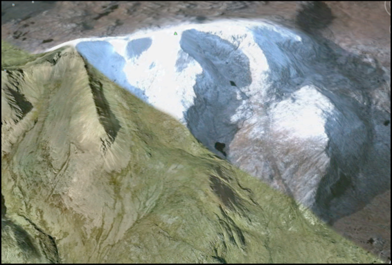
The complete tour takes about 17 minutes; if you are desk-bound for lunch, we’d recommend chomping your sandwiches as the Northwest Highlands float by underneath for a more relaxing break than might usually be the case.
We’ve kept it simple for now - no narration or music to accompany the scenery, but we might get bold in the future. We hope you enjoy the view.
Download Seventeen minutes in the Northwest Highlands.
Google MountainView 1
Thursday, 14 July, 2011. Filed under: Landscapes | Views & Scenery
Even without clicking through to the location of this snap from the Google Street View car, your landscaper’s eye will instinctively know that we’re in the Lake District - the walls, the shape of the mountains and the tumbling beck are all excellent clues to the general location.
View Larger Map
This view, near the top of the winding lane that follows the Watendlath Beck from Derwent Water up to its eponymous Tarn, complete with lay-by encapsulates everything that is wonderful about the Lake District the glaciers left behind.
View Larger Map
This view, near the top of the winding lane that follows the Watendlath Beck from Derwent Water up to its eponymous Tarn, complete with lay-by encapsulates everything that is wonderful about the Lake District the glaciers left behind.
English Riviera Geopark film
This film, narrated by a child, is a lovely crash-course introduction to geology in general and to the English Riviera Geopark in particular - the world’s first urban geopark.
Solstice special:
The Day that Stonehenge Disappeared
Tuesday, 21 June, 2011. Filed under: Views & Scenery
In light of the Solstice, we celebrate the summer with an article on the Stonehenge Landscape.
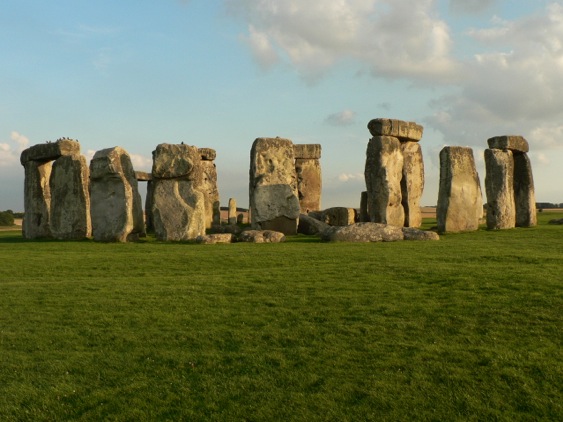
I struggle to keep up on an unexpectedly warm autumn evening as I galumph my way across rough downland in pursuit of a tour guide. Pat Shelley is leading me from one location which boasts a million visitors a year to another that only a few hundred manage to see. I’m grateful for his expertise because across the hummock-strewn field ahead lies Stonehenge Cursus, a curious feature every bit as enigmatic as the main attraction.
I had thought that getting off the trampled track so close to the well-beaten A303 would be a near impossibility. To do so within sight of Stonehenge which is, after all, the acme of tourist attractions, would be harder still. So, when Shelley - a local tour guide I had met the year before - got in contact offering a social drink and an evening around the stone circle, I have to say I was very much looking forward to the beer.
Shelley’s enthusiasm for, and knowledge of, Stonehenge is unsurpassed. He’s spent years showing tourists around the area and has helped out on many archaeological digs, a background that helps him synthesize all the latest theories and ongoing work around the monument, seemingly at the drop of a hat. He wanted to show me something that very few tourists get a grip on - that the landscape around Stonehenge is every bit as important as the stones themselves. Recent archaeological work has uncovered many links between it and other monuments - among them, Durrington Walls and Woodhenge to the east and ‘Bluestonehenge’, discovered earlier this year by the Stonehenge Riverside Project next to the River Avon - and these links suggest that the Stonehenge Landscape was, indeed, huge.
The Stonehenge Cursus, recently dated to between 3630 and 3375 BC, is nearly two miles long and ranges from three to five hundred feet in width. On the Ordnance Survey map it appears as a prominent rectilinear feature amongst the blunderbuss grapeshot of Neolithic and Bronze Age barrows that lie spattered across the Wiltshire landscape. So it comes as a shock that the Cursus is barely perceptible on the ground - an indeterminate ditch and bank arrangement which only resolves itself as a wide gap cut through a hangar of trees at its western end.
After a few moments of disappointment, I adjust my expectations and imagine the sheer scale of the endeavour. I remind myself that the most spectacular forms on the planet are often ones for which no particular purpose springs to mind, enchanted as we are by the brute pointlessness of ancient lines on the landscape - lines which can only really be appreciated from above. Indeed, nobody has the slightest idea what it or any of the hundred or so similar features in Britain are actually for; all explanation defaults to a mumble of ‘ritual use’, which, Shelley informs me, is an archaeological euphemism for ‘we don’t really know’.
One thing is certain, however: apart from what remains of the outline of this great human mark, there is precious little archaeology actually on it. Given our ancestors’ implied lack of care with their coins, combs, tools and artefacts, it is odd that a huge area that probably took thousands of man hours to construct should be so bereft of human clutter. It is almost as if it had been kept consciously clean.
While I mumble about the minimalist Neolithic to myself, my guide takes off across the field, promising to show me something that I would never forget - as if in compensation for showing me something that I could barely see.
As anyone who has spent a merry hour or two queuing on the A303 will tell you, Stonehenge is a prominent feature. While it melts sympathetically into views of its immediate vicinity from the middle distance, at close quarters you just can’t take your eye off the thing: it dominates the landscape and, moreover, it seems to be following me around now, forever in my peripheral vision in a way I imagine it must have been for our ancestors. I catch up with my guide at the foot of a low eminence, turn around and it has vanished - which is disturbing, given that it is only a few hundred yards away.
We are on The Avenue, a grand, curving earthwork ‘road’ almost two miles long that seems to be a processional walkway from the River Avon to the henge. Shelley is motioning to me to walk up towards the circle and, as I do, I can’t help gasping as the familiar outline of Stonehenge reappears, rising above the grass and thistles in a strange inversion of druidic tradition. It suddenly becomes clear that Stonehenge is more than a familiar pile of stones, but part of a larger landscape, even a stage-managed experience. Like the best theatre, Stonehenge can still surprise.
Applecross Cave discovered
Sunday, 05 June, 2011. Filed under: Landscapes
According to the BBC website - and we’re indebted to BLC member Fiona Wilson for pointing this out to us - Grampian cavers have discovered a very large cave chamber in one of the most remote areas of Scotland.
The cave, near Applecross on the west coast, is 180 metres long and has stalactites measuring up to 2 metres. For Metropolitan types, that’s the length of ten bendy-buses, or Russell Square. More information at the link.
The cave, near Applecross on the west coast, is 180 metres long and has stalactites measuring up to 2 metres. For Metropolitan types, that’s the length of ten bendy-buses, or Russell Square. More information at the link.
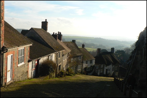
Famous landscapes:
Gold Hill, Shaftesbury, Dorset
Friday, 14 January, 2011. Filed under: Landscapes | Views & Scenery
A couple of snaps taken early in January on one of the most famous hills in the UK - Gold Hill in the thriving hilltop town of Shaftesbury in Dorset. It’s famous because Ridley Scott filmed a commercial here in the 1970s - an advertisement for Hovis that, in many ways - namely it’s sepia toned air of nostalgia, was the direct antithesis of Bladerunner.
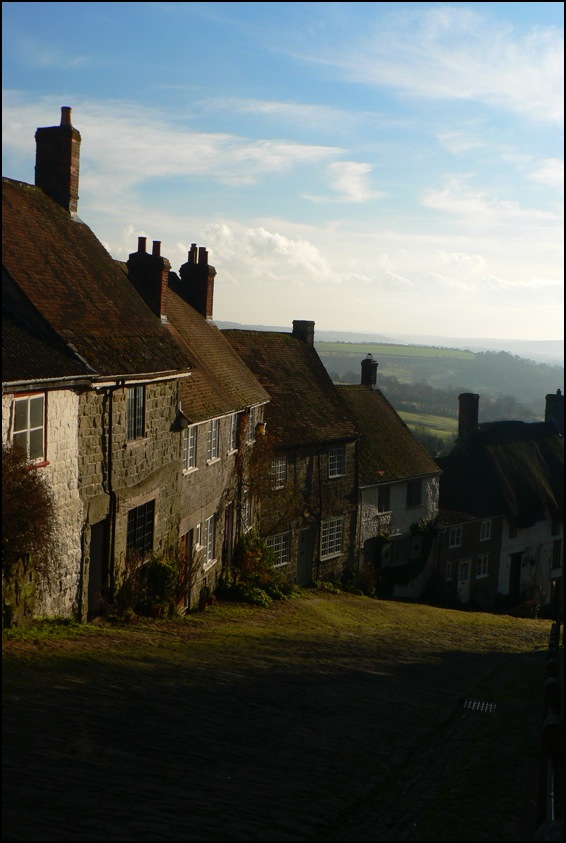
The views look south towards a landscape made from Cretaceous chalk and greensand and older mudstones and siltstones from the Jurassic period. To the west of Shaftesbury the Jurassic continues - with many of the same limestones that are found in the Midlands cropping up, lending the area its Cotswolds atmosphere.
The views look south towards a landscape made from Cretaceous chalk and greensand and older mudstones and siltstones from the Jurassic period. To the west of Shaftesbury the Jurassic continues - with many of the same limestones that are found in the Midlands cropping up, lending the area its Cotswolds atmosphere.
Landscape blog
Tuesday, 16 November, 2010. Filed under: Landscapes
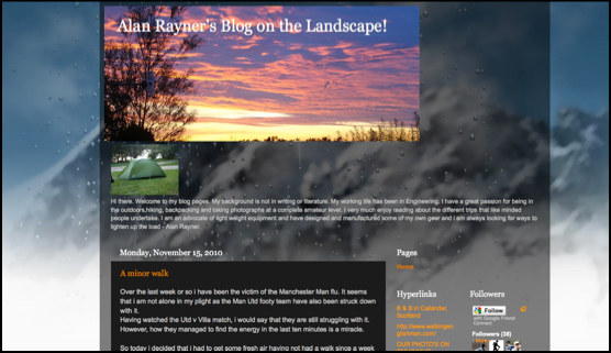
On our occasional trawls around the internet in search of snippets to amuse we often find hardcore walking and rambling sites - all kit and kaboodle and useful instructions for getting a platoon to the top of a mountain. All well and good but, apart from the picture from the summit, the journey always seems more like a technical challenge than an engagement with the landscape.
We were pleased, then, to find Alan Rayner’s Blog on the Landscape. Alan’s posts are illustrated with some thoughtfully composed photographs of this and that along the way - mostly natural features, plants and fungi - and his woodland shots, often difficult to capture well - are lovely.
Kit fetishists will be pleased to discover that Alan - an engineer by trade - appears to have designed and manufactured some of his own lightweight equipment and is always on the lookout for more, but a genuine love of the landscape permeates the blog. Recommended.
Night time views - Salisbury
Tuesday, 24 August, 2010. Filed under: Photography | Views & Scenery
Sometimes it’s hard to get the full beauty of a viewpoint amongst all the clutter of the day, especially on our crowded collection of islands. In history, when buildings were few and far between and we hadn’t yet divided the country up into interstitial parcels of land between roads - as is the psychological outcome of the motoring atlas - the views over the landscape we had must have felt very different. As mentioned in The Lie of the Land, our ancestors had a very different relationship with views from high ground - upland (even a range of hills as modest as the Cotswolds) had a terror all of its own and a view over a wide vale like the Severn would have come as a welcome relief.
What buildings there were nestling in the valleys would have had greater significance - especially after a long journey or pilgrimage across the country. I hope that this view of Salisbury Cathedral - which for hundreds of years would have been the tallest building in the western world - captures something of the awe a long-distance medieval traveller would have felt 700 years or so ago. By removing the detail of the town that has grown up around it, with its ring road, modern development and other 20th and 21st Century clutter and even with the housing development in the foreground, this magnificent old cathedral still takes your breath away.
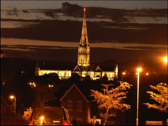
What buildings there were nestling in the valleys would have had greater significance - especially after a long journey or pilgrimage across the country. I hope that this view of Salisbury Cathedral - which for hundreds of years would have been the tallest building in the western world - captures something of the awe a long-distance medieval traveller would have felt 700 years or so ago. By removing the detail of the town that has grown up around it, with its ring road, modern development and other 20th and 21st Century clutter and even with the housing development in the foreground, this magnificent old cathedral still takes your breath away.
More pictures from trains
Monday, 19 July, 2010. Filed under: Landscapes | Views & Scenery
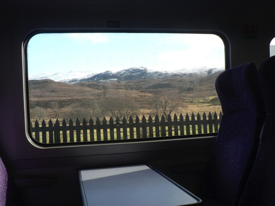
I’ve added a few more photos to the gallery of landscapes taken from trains. It seems like an unconventional way of capturing scraps of scenery as they zoom by and an excellent mental diversion when the novelty of getting out and about wears thin which, as any commuter on Britain’s railways will tell you, can be quite quick.
If you have some train pictures you want to share, feel free to add some in the comments below.
Monstrous Carbuncle
I like Dorset - as mentioned in this week’s Lay-by of the Week, it is where a lot of the ideas for The Lie of the Land came from and it is a county that seems to have as many different facets as it has market towns.
But one of those towns – and not just any old market town, but Dorset’s county town – will never be the same again. For Dorchester has been tainted by its association with the monstrous carbuncle that is HRH Prince Charles’ Poundbury or, to give it a name accidentally arrived at in a Freudian slip of the tongue, Poundland.
View Monstrous Carbuncle in a larger map
This grotesque and repulsive display of architectural pus sits on the eastern horizon as you approach Dorchester from the west. The awful buildings infect the surrounding landscape with their weak-minded parody of a passing resemblance to a rough similarity to a half-remembered Tuscan hill-top village. Who-ever presided over this inferior and wholly unaesthetic effort should be shot through the lungs with high-velocity 2H pencils.
Some of Poundbury is well-executed, even if it is obviously the work of a cobwebbed mind. While the Duke of Cornwall proclaims his love of traditional vernacular architecture and actually has interesting and useful ideas about the sustainability of communities, his biggest showcase looks like a malformed bleb from the side of the A35.
Win a hamper in our landscape photo competition.
To celebrate the launch of Lie of the Land, The British Landscape Club’s under-the-field-guide to the British landscape, we are running a photography competition to find Britain's best photographed landscape.
So get snapping those buxom hummocks, discordant coastlines and stone circles and submit them to the Lie of the Land Flickr photo pool at http://www.flickr.com/groups/lieoftheland/.
The winner - who will win a lovely picnic hamper - will be announced July 30 2010 Leading up to the announcement we will feature ten photos a week right here on the website. There will be also be runner-up prizes of signed copies of Lie of the Land.
For general competition terms and conditions go to:
http://www.panmacmillan.com/displayPage.asp?PageID=3823
Please be assured that your photos will only be used in connection with this competition and any publicity it generates - which may include the websites of national and local newspapers. The submitter retains all copyright to their photos and the right to a byline/credit where ever it is used.
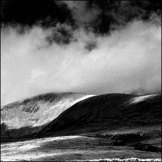
Lay-by of the Week
Monday, 15 March, 2010. Filed under: Landscapes | Views & Scenery
From the A498 in Snowdonia, North Wales comes this splendid post-glacial landscape with views of Llyn Gwynant, a mile or so south of the Pass of Llanberis, a stone's throw from Snowdon itself.
View Larger Map
If you pan to the right, you'll see the lay-by itself. Further down the A498 there is a closer view of Llyn Gwynant on a sharp bend of the road and excellent views up the valley - an enchanting vista on a fresh spring morning.
View Larger Map
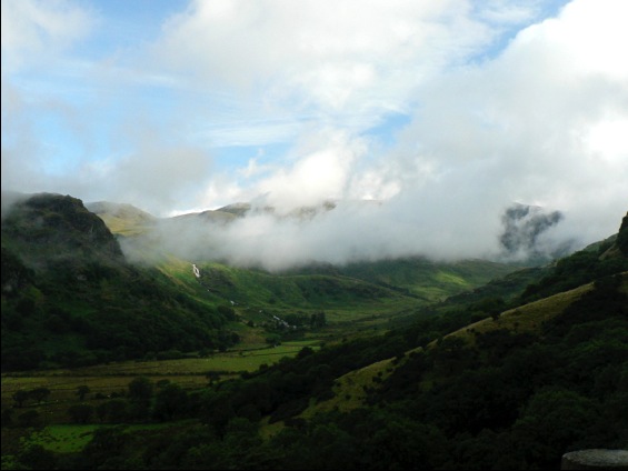
View up the Gwynant Valley.
View Larger Map
If you pan to the right, you'll see the lay-by itself. Further down the A498 there is a closer view of Llyn Gwynant on a sharp bend of the road and excellent views up the valley - an enchanting vista on a fresh spring morning.
View Larger Map
View up the Gwynant Valley.